


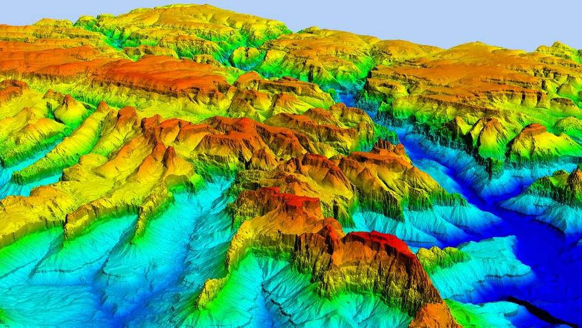
A Digital Elevation Model (DEM) represents the elevation of the Earth’s surface as a grid of elevation values. It serves as essential tools for understanding the Earth’s topography, hydrology, and landforms. Researchers, geologists, and environmental scientists rely on DEMs for various purposes, including terrain analysis, flood modeling, and urban planning.
Creating a DEM using open-source software like PyGMTSAR (Python InSAR) is a prime example of how modern technology makes complex processes accessible and fast. With just one click, you can start the processing and obtain the results for a satellite DEM. This example and many other interactive InSAR examples with 3D visualization are available on the InSAR.dev platform.
The digital elevation model is created from radar images obtained by Sentinel-1 data in just a few minutes on internet-connected devices. This speed and accessibility make the technology suitable for everyone, without the need for high-speed internet, large disk space, or a powerful computer.
Public radar satellites, such as Sentinel-1, scan our planet day and night, capturing the reflected signal as raster images for subsequent processing. These images store complex phase values of the reflected signal and can be used to obtain various information about the condition and movements of the Earth’s surface and atmospheric properties. The simplest form of processing involves calculating the signal amplitude to produce a grayscale image, similar to optical photography but independent of time of day and cloud cover.
The real potential of radar satellites is revealed when processing complex data. The radar wavelength of Sentinel-1 is 56 mm, allowing for the registration of precise heights and displacements of the Earth’s surface on the order of fractions of a millimeter. If the surface subsides by a millimeter, the radar beam travels an additional distance of 1 millimeter to the surface and back, totaling 2 millimeters. This small delay can be recorded and processed.
In addition to surface displacements, the images contain what is known as atmospheric phase, which is the signal delay as it passes through the atmosphere. In cases of strong atmospheric turbulence or cloud cover, the atmospheric phase delay can equate to hundreds of millimeters of surface displacement. Therefore, precise separation of different sources of signal change is required to achieve high-accuracy surface monitoring.
For such precise calculations, it is necessary to know the satellite’s orbit accurately and compensate for orbital errors. Solid Earth tides caused by the moon and the sun also influence the data, which can be compensated for analytically or based on spatial spectrum data.
For illustrative and educational purposes, a pair of “ideal” images is chosen from a well-reflecting rocky area with low cloud cover. In industrial use, various methods for processing a series of images are applied. For DEM construction, sub-millimeter accuracy is not required, so for a well-chosen area, data analysis is performed automatically without parameter selection. When vegetation and cloud cover are present, additional operations are needed to separate these signal components and assess result accuracy.
Sentinel-1, the only global publicly available satellite, is currently in orbit. Nearly a decade of imagery is available, allowing us to build detailed topography and study surface displacements, infrastructure, earthquake effects and many other processes and phenomena on our planet. Two new Sentinel-1 radar satellites and the joint NISAR satellite from NASA and the Indian Space Research Organization (ISRO) are expected to be launched by the end of the year.


